In this guide
💡 The Short Version: Often hailed as “Iceland in Miniature” (Ísland í hnotskurn), the Snæfellsnes Peninsula packages Iceland’s volcanic topography into a 450-kilometre day-trip loop that takes 11 to 12 hours to complete from Reykjavik. Signature highlights include the wild seal colony at Ytri Tunga, the isolated black wooden chapel at Búðir, the jagged sea arches of Arnarstapi, the black pebble shore and ancient lifting stones at Djúpalónssandur, and the striking conical peak of Kirkjufell near Grundarfjörður. Parking fees total roughly 2,000 ISK across the day. Or book a tour: let a seasoned local driver handle the seven hours of behind-the-wheel transit by booking GetYourGuide’s Snaefellsnes Peninsula Full-Day Tourad.
Jutting westward into the cold waters of Faxaflói and Breiðafjörður, the Snæfellsnes Peninsula is dominated by the, snow-clad cone of Snæfellsjökull (1,446 metres), the dormant stratovolcano made internationally famous in 1864 by Jules Verne as the subterranean entrance portal in A Journey to the Centre of the Earth. For travellers seeking coastal scenery with fewer tour convoys than the Golden Circle or the South Coast, Snæfellsnes offers an unhurried, evocative wilderness circuit.
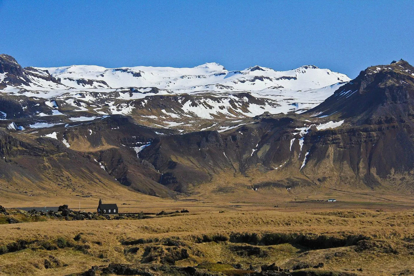 Búðakirkja on the Búðir meadows. Photo: cjuneau, Wikimedia Commons, CC BY 2.0.
Driving itinerary and time management
To complete the 450-kilometre loop safely and enjoy relaxed coastal walks, leave central Reykjavik no later than 07:30. Travel north through the 5.7-kilometre sub-sea Hvalfjörður tunnel on Route 1 to Borgarnes, then branch onto Route 54 heading west along the peninsula’s southern shore.
| Excursion stop | Distance from previous point | Route segment | Recommended dwell time | Parking fee | Primary highlights |
|---|---|---|---|---|---|
| Borgarnes (Fuel & coffee stop) | 75 km from Reykjavik | Route 1 | 20 minutes | Free | Settlement Centre, bakery, fuel top-up |
| Ytri Tunga Seal Beach | 90 km from Borgarnes | Route 54 | 45 minutes | 900 ISK | Golden sandbar, wild harbour seals |
| Búðir Black Church | 15 km from Ytri Tunga | Route 54 / Búðavegur | 30 minutes | Free | 19th-century pitch-black chapel, lava fields |
| Arnarstapi Coastal Cliffs | 15 km from Búðir | Route 574 | 1 to 1.5 hours | Free | Gatklettur sea arch, cliff walk to Hellnar |
| Djúpalónssandur Beach | 16 km from Arnarstapi | Route 574 | 1 hour | 1,100 ISK (Park fee) | Black pebble bay, ancient lifting stones, shipwreck |
| Saxhóll Volcanic Crater | 12 km from Djúpalónssandur | Route 574 | 30 minutes | Free | Metal stairs ascending 100 m volcanic cone |
| Kirkjufell & Kirkjufellsfoss | 45 km from Saxhóll | Route 54 | 45 minutes | 1,000 ISK | Pyramidal mountain, tiered waterfalls |
| Return to Reykjavik | 180 km from Kirkjufell | Route 54 to Route 1 | 2.5 hours | None | Southbound drive via Borgarfjörður |
Stop 1: Ytri Tunga seal colony
While the majority of Icelandic beaches consist of pulverized jet-black basalt sand, Ytri Tunga is a notable exception, boasting pale golden sands backed by grassy dunes.
The offshore rocky reefs provide an ideal haul-out sanctuary for wild harbour seals (Phoca vitulina) and larger grey seals (Halichoerus grypus). The animals can be observed basking lazily on seaweed-covered boulders or swimming curiously near the shoreline.
Viewing guidelines: Visit within two hours of low tide when the largest number of offshore rocks are exposed. Keep a respectful distance of at least 20 to 30 metres from resting seals; never encircle an animal or cut off its direct escape path into open water. Flying camera drones directly over the colony is prohibited under national wildlife protection codes.
Parking details: 900 ISK per vehicle, enforced via automated automatic number-plate recognition cameras. Pay online at Checkit.is or at the car park machine.
Stop 2: Búðir and Búðakirkja
Situated on the edge of the sprawling 8,000-year-old Búðahraun lava field, Búðir was once a thriving fishing trade post. Today, the settlement consists only of the historic country hotel Hótel Búðir and the well-known black church, Búðakirkja.
First constructed from timber in 1703 and rebuilt in its current form in 1848, the church owes its distinctive appearance to coats of black pitch painted over the exterior cladding to protect the building against fierce Atlantic gales and salt spray. Set against windblown grasses, rugged basalt ridges, and the gleaming white glaciers of Snæfellsjökull, the solitary chapel is one of Iceland’s most photographed architectural landmarks.
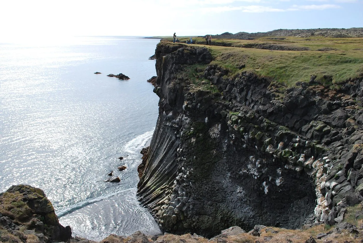 Basalt cliffs at Arnarstapi. Photo: Chmee2/Valtameri, Wikimedia Commons, CC BY 3.0.
Stop 3: Arnarstapi and the coastal cliff path
Arnarstapi is a historic fishing hamlet tucked beneath the pyramid peak of Mount Stapafell. The shoreline here features cliff architecture forged where cooling basalt lava met freezing seawater.
The Arnarstapi-Hellnar coastal trail
From the small harbour marked by Ragnar Kjartansson’s towering stone sculpture of the guardian spirit Bárður Snæfellsás, a 2.5-kilometre clifftop footpath leads west to the hamlet of Hellnar. Highlights along the walk include:
- Gatklettur: A colossal wave-eroded basalt arch through which crashing swells surge, creating explosive plumes of white foam.
- Cliff Nesting Colonies: Between May and August, the basalt columns and vertical sea crags host dense colonies of black-legged kittiwakes, northern fulmars, and Arctic terns.
- Fjöruhúsið Café at Hellnar: A rustic timber café perched over the rocky inlet of Hellnar, known for homemade fish soup and freshly baked waffles.
Allow 60 to 90 minutes to complete the walk out and back, or simply stroll the first 500 metres around the Arnarstapi headland if time is constrained.
Stop 4: Djúpalónssandur black pebble beach
Situated within the official boundaries of Snæfellsjökull National Park, Djúpalónssandur is an inlet of smooth, pitch-black basalt pebbles known locally as perluperlur (black pearls).
Visitors descend to the shoreline through the Nautastígur (Bull’s Path), cutting between contorted, ten-metre-high volcanic rock spires.
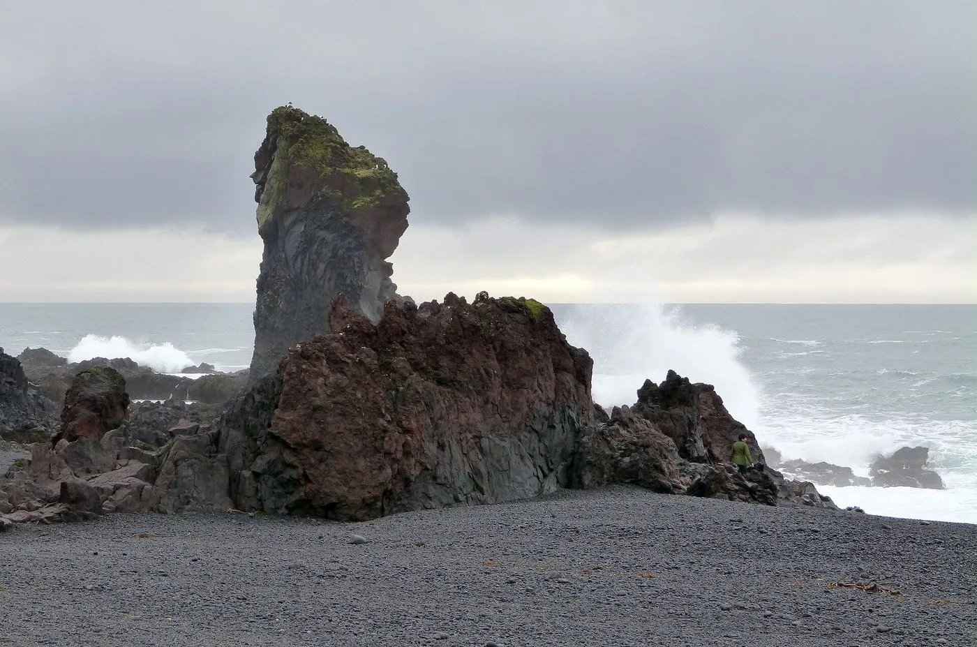 A sea stack at Djúpalónssandur. Photo: gailhampshire from Cradley, Malvern, U.K, Wikimedia Commons, CC BY 2.0.
The ancient lifting stones (Aflraunasteinar)
Near the entrance to the beach sit four rounded stones that tested the physical strength of Icelandic fishermen throughout centuries of open-rowboat fishing:
- Amlóði (The Weakling): 23 kg (50 lbs). Lifting this was considered the bare minimum, earning the lifter embarrassment rather than work.
- Hálfdrættingur (The Half-Carrier): 54 kg (119 lbs). Lifting this stone to hip height qualified a man to sign on as an oarsman and claim half a share of the boat’s catch.
- Hálfsterkur (The Half-Strong): 100 kg (220 lbs). The standard qualifying threshold for a full adult fisherman’s wage aboard regional rowing vessels.
- Fullsterkur (The Fully Strong): 154 kg (340 lbs). Reserved for men of physical prowess.
Attempting the stones is permitted, but lift with your legs and exercise extreme caution to prevent back injury.
The wreck of the Epine GY7
Scattered across the black pebbles lie the rusted iron plates, winches, and boilers of the Epine, a British steam fishing trawler from Grimsby that was driven onto the rocks during a ferocious blizzard on the night of 13 March 1948. Fourteen crew members perished in the freezing surf, while five were miraculously pulled to safety by the brave local rescue team of ICE-SAR. The iron debris is protected as a solemn historical memorial; taking any rusted fragment from the beach is illegal.
Safety note: Like Reynisfjara on the South Coast, Djúpalónssandur experiences unpredictable sneaker waves. Stay well clear of the churning shore break.
Parking details: A single parking ticket of 1,100 ISK covers your vehicle across all paid parking lots within Snæfellsjökull National Park for that day.
Stop 5: Kirkjufell and Kirkjufellsfoss
Crossing from the southern shore over to the north coast via Route 54 or the Fróðárheiði mountain pass, you arrive at the sheltered fjord of Grundarfjörður, home to Kirkjufell (Church Mountain).
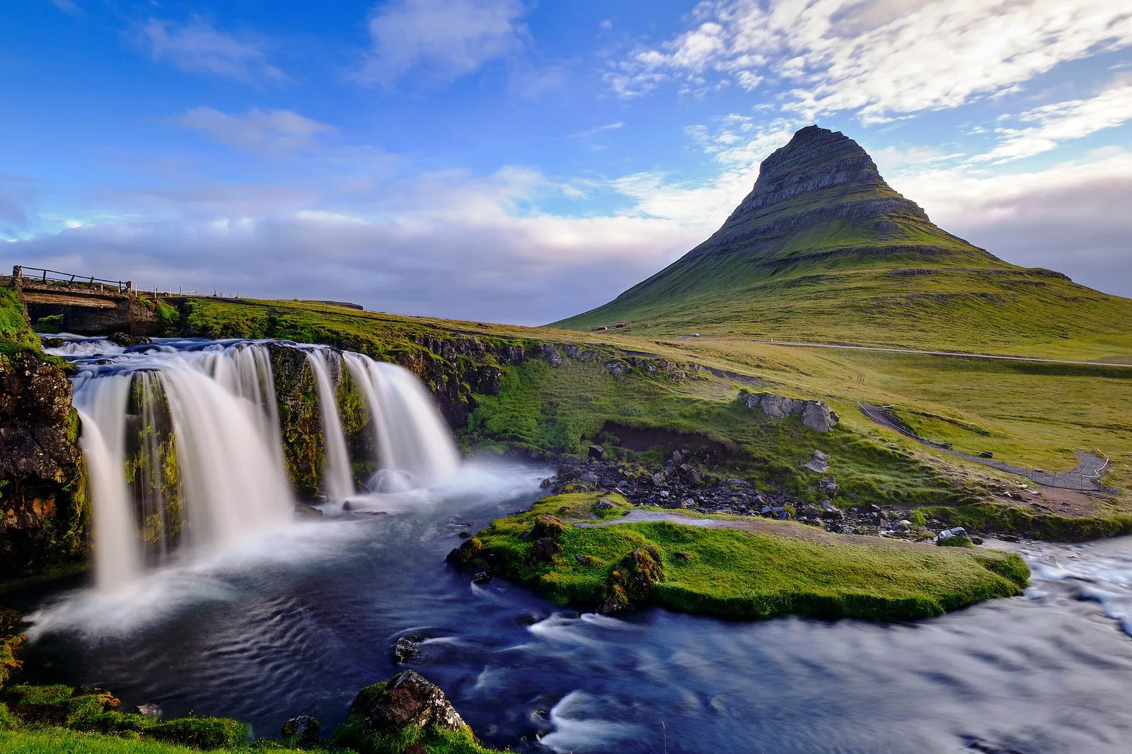
Rising 463 metres straight out of the water, Kirkjufell features a tapered, triangular silhouette created through millions of years of glacial erosion during the Ice Ages. The mountain achieved international celebrity after appearing as “Arrowhead Mountain” in seasons six and seven of the television epic Game of Thrones.
The classic photograph is taken from the banks of Kirkjufellsfoss, a three-tiered glacial cascade located across the road from the mountain base. Position yourself on the walking trail above the falls to frame the cascading water in the foreground and the symmetrical spire of Kirkjufell in the background.
Parking details: A fee of 1,000 ISK applies at the dedicated Kirkjufellsfoss car park, payable via the Parka smartphone application.
Tour options and bookings
Navigating 450 kilometres of sub-arctic coastal highways, unpaved gravel pull-ins, and changing mountain weather can be taxing for independent drivers. Booking an organised excursion allows you to relax and absorb the scenery.
From Reykjavik: Snaefellsnes Peninsula Full-Day Tourad
From 18,100 ISK · 4.7 stars from 3,947 reviews · 11 hours · Instant confirmation
The definitive full-day coach tour of the Snæfellsnes Peninsula. This excursion covers every key sight: seal-watching at Ytri Tunga, photography at Búðir black church, a guided coastal walk along the cliffs of Arnarstapi, beachcombing at Djúpalónssandur, panoramic views of Snæfellsjökull glacier, and the waterfalls of Kirkjufell. Includes central Reykjavik hotel pickups, free onboard Wi-Fi, and 24-hour cancellation flexibility.
Snaefellsnes Peninsula Small-Group Tour from Reykjavikad
From 17,400 ISK · 4.6 stars from 320 reviews · 11 hours · Minibus
Experience Snæfellsnes in a small, personalised group capped at 19 participants aboard a modern minibus. The smaller group allows access to secluded vantage points and extra time at each scenic stop, guided by an engaging local driver-storyteller.
Reykjavik: Small-Group Snaefellsnes Day Tripad
From 18,900 ISK · 4.8 stars from 277 reviews · 11 hours · Expert guide
A premium day trip focusing on folklore, geology, and local Icelandic cuisine. Enjoy leisurely coastal strolls and seasonal culinary samples along the way, with pickup and drop-off included at all central Reykjavik accommodations.
Practical driving advice for self-drivers
- Fuel Logistics: Always fill your petrol tank to full in Borgarnes before turning onto Route 54. Petrol stations on the peninsula are sparse, unstaffed, and located primarily in small north-coast villages (Ólafsvík, Grundarfjörður, and Stykkishólmur). Pumps require a credit or debit card with a four-digit PIN.
- Dining Recommendations: Pick up lunch supplies at the supermarket in Borgarnes, or stop for fresh seafood soup and local cod at Sker Restaurant in Ólafsvík or Bjargarsteinn Mathús in Grundarfjörður.
- Winter Driving Cautions: The mountain passes linking the south and north shores (especially Route 56 Vatnaleið and Fróðárheiði) are vulnerable to severe drifting snow and sudden icing from November through April. If high winds or blizzards are forecast, stick to the low-lying coastal roads or join a professional tour.
For comparisons between all major day excursions from the capital, browse our comprehensive guide to day trips from Reykjavik and plan your base using our where to stay in Reykjavik neighbourhood guide.
Common questions
Can you tour the Snæfellsnes Peninsula in a single day from Reykjavik?
Yes, though it requires an early start and an 11 to 12-hour commitment. The complete driving circuit spans approximately 450 kilometres and roughly seven hours of pure behind-the-wheel driving time. Allocating 30 to 60 minutes for each primary sight ensures you complete the loop comfortably before sunset.
Why is Snæfellsnes frequently described as 'Iceland in Miniature'?
Within a narrow 90-kilometre finger of land, the peninsula compresses virtually every geological landscape found across Iceland: a towering glacier-capped stratovolcano (Snæfellsjökull), sprawling mossy lava fields, basalt sea arches, volcanic pebble beaches, golden seal sands, fjords, and fishing hamlets.
What is the historical significance of the lifting stones at Djúpalónssandur?
For centuries, captains of fishing rowing boats tested prospective rowers on four smooth sea-worn basalt boulders resting on the black beach: Amlóði (23 kg, 'Weakling'), Hálfdrættingur (54 kg, 'Half-Carrier'), Hálfsterkur (100 kg, 'Half-Strong'), and Fullsterkur (154 kg, 'Fully Strong'). To earn a berth and full wages aboard a fishing vessel, a man had to hoist at least the 100 kg Hálfsterkur onto a hip-height boulder.
Are roads on the Snæfellsnes Peninsula open throughout the winter?
The paved primary highways (Route 54 and Route 574) are cleared of snow regularly by road administration crews. However, coastal gales and drifting blizzards across mountain passes such as Fróðárheiði frequently prompt temporary closures. Review road status at umferdin.is before departing, or book a guided minibus excursion.