In this guide
💡 The Short Version: The Golden Circle (Gullni hringurinn) is a 240-kilometre loop across south-western Iceland that takes 7 to 9 hours. The core route takes in three stops: Þingvellir National Park (a rift valley where tectonic plates diverge and the site of Iceland’s first parliament, founded in 930), Geysir geothermal area (where Strokkur erupts every few minutes), and Gullfoss (a two-tiered glacial waterfall). Adding the volcanic crater lake of Kerið rounds off the loop. Self-driving adds 1,000 ISK parking at Þingvellir and 700 ISK a person for Kerið, plus petrol. Or book a tour: take the hassle out of winter road conditions and parking logistics by booking GetYourGuide’s Golden Circle Full-Day Tour with Kerid Craterad.
Originating in the early 20th century as a day excursion for visiting dignitaries and foreign naturalists, the Golden Circle remains the benchmark day trip from Reykjavik. Its enduring popularity stems from its accessibility: all three anchor attractions lie within a two-hour drive of downtown hotels, linked by paved, two-lane highways that bypass Iceland’s rough interior tracks.
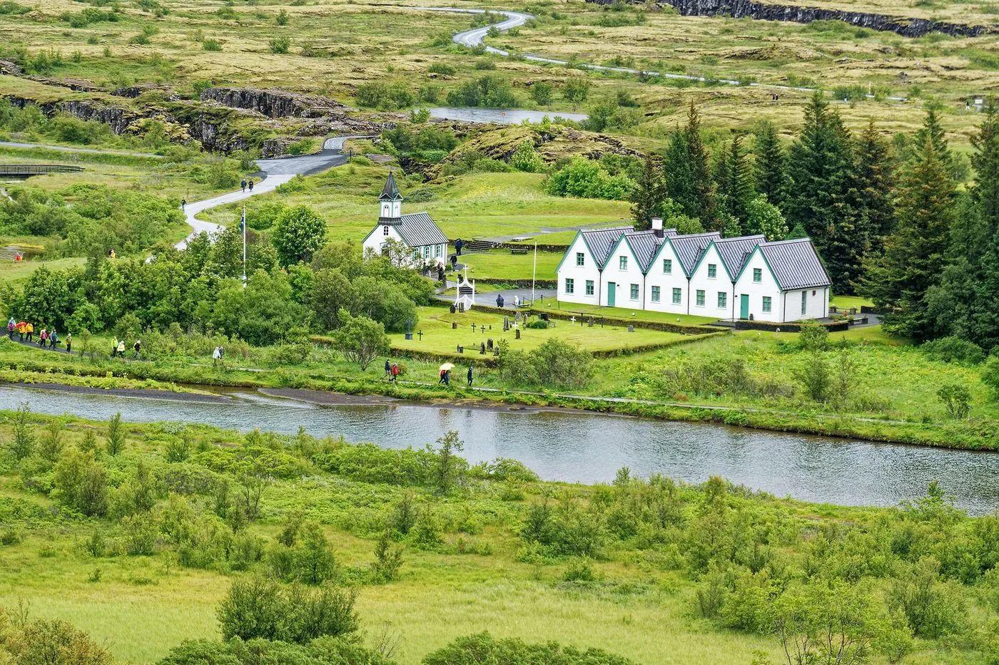 Þingvellir church and farmhouse beside the Öxará river. Photo: Holger Uwe Schmitt, Wikimedia Commons, CC BY-SA 4.0.
Route overview, distances and timing
The classic route proceeds clockwise from Reykjavik, minimising driving fatigue by placing the longest single driving leg at the very start of the day when you are freshest.
| Excursion stop | Distance from previous stop | Highway route | Recommended duration | Parking / entry fees | Core sights & activities |
|---|---|---|---|---|---|
| 1. Þingvellir National Park | 47 km from Reykjavik | Route 36 | 1.5 to 2 hours | 1,000 ISK per car (all-day) | Almannagjá rift, Lögberg, Öxarárfoss, Silfra fissure |
| 2. Geysir (Haukadalur) | 60 km from Þingvellir | Route 37 / Route 35 | 1 hour | Free to walk the geothermal area | Strokkur eruption, Blesi spring, bubbling mud pots |
| 3. Gullfoss Waterfall | 10 km from Geysir | Route 35 | 1 hour | Free to view the falls | Two-tiered falls, canyon viewpoints, spray platform |
| 4. Friðheimar Greenhouse | 25 km from Gullfoss | Route 35 | 1 to 1.5 hours | Free parking | Tomato greenhouse restaurant, horse stables |
| 5. Kerið Volcanic Crater | 30 km from Friðheimar | Route 35 | 45 minutes | 700 ISK per person | Red caldera rim, crater lake walking trail |
| Return to Reykjavik | 67 km from Kerið | Route 35 to Route 1 | 55 minutes | None | Drive through Selfoss and over Hellisheiði heath |
Stop 1: Þingvellir National Park (Thingvellir)
Located 47 kilometres north-east of Reykjavik, Þingvellir National Park is both a geological marvel and the historic cradle of the Icelandic nation. Inscribed as a UNESCO World Heritage site in 2004, it occupies a tectonic rift valley where the North American and Eurasian continental plates are drifting apart at a rate of approximately two centimetres per year.
Historical significance: the Alþingi
In 930 AD, Norse settlers established the Alþingi (national assembly) at Þingvellir, establishing one of the earliest parliamentary institutions in human history. Every summer for two weeks, clan chieftains (goðar) and freeholders gathered here from across the island to establish laws, resolve bloody feuds, and arrange marriages. At the Lögberg (Law Rock), the elected Lawspeaker (Lögsögumaður) recited one-third of the nation’s unwritten legal code from memory each year.
Geological highlights to explore
- Almannagjá Canyon: A massive pedestrian pathway running between sheer walls of black basalt on the eastern boundary of the North American tectonic plate.
- Öxarárfoss: A 13-metre waterfall that tumbles over the rim of the Almannagjá rift into a boulder-strewn pool. Local sagas claim early settlers diverted the Öxará river into the canyon to provide clean drinking water for assembly delegates.
- Silfra Fissure: A freshwater rift flooded with glacial meltwater filtered through underground porous lava fields for 30 to 100 years. Renowned for underwater visibility exceeding 100 metres, it hosts well-known snorkelling and drysuit diving excursions.
- Þingvallakirkja: A quaint wooden parish church consecrated in 1859, surrounded by a peaceful cemetery holding the graves of beloved national poets Jónas Hallgrímsson and Einar Benediktsson.
Parking details: A flat fee of 1,000 ISK covers standard passenger cars for the entire day across all park car parks (P1 at Hakið visitor centre, P2 at Efri-Vellir, and P5 at Valhöll). Pay via license-plate recognition on the Checkit.is portal or at the touch-screen payment terminals in the visitor centre.
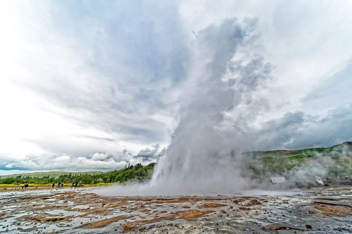 Strokkur erupting at Haukadalur. Photo: Holger Uwe Schmitt, Wikimedia Commons, CC BY-SA 4.0.
Stop 2: Geysir and Strokkur (Haukadalur)
Sixty kilometres east of Þingvellir lies Haukadalur, a geothermal valley packed with smoking fumaroles, vivid cyan thermal pools, and boiling mineral mud pots.
The Great Geysir and Strokkur
The valley gave the English language the universal word “geyser”, derived from the Old Norse verb gjósa (to gush). The titular Great Geysir, recorded in historical annals as far back as 1294, previously erupted boiling water up to 70 metres into the air. Today, it lies mostly dormant, erupting only rarely after major seismic activity.
Fortunately, its neighbour Strokkur (The Churn) is exceptionally reliable. Every 6 to 10 minutes, the thermal water inside the vent begins to pulse. A massive turquoise dome of boiling water swells above the rim before violently exploding into a column of scalding water and white steam reaching heights of 15 to 30 metres.
Safety and visiting advice: Keep strictly behind the perimeter safety ropes and stay on marked gravel pathways. The ground water here reaches temperatures exceeding 100°C, and the thin mineral crust can give way without warning. Always observe which direction the prevailing wind is blowing and position yourself on the upwind side of the vent to avoid scalding droplets and dense sulfurous steam clouds.
Stop 3: Gullfoss Waterfall (The Golden Falls)
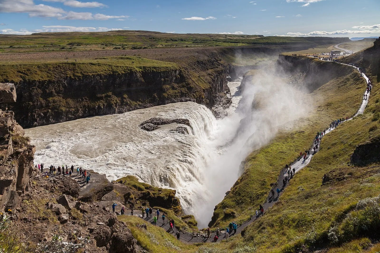
Just 10 kilometres past Geysir on Route 35, Gullfoss is Iceland’s most famous cataract. The Hvítá (White) river, carrying torrential meltwater from the vast Langjökull glacier, races across a wide volcanic expanse before plummeting down a wide three-step staircase into a rugged 70-metre-deep canyon.
The waterfall plunges in two stages: an upper 11-metre drop followed immediately by a sheer 21-metre plunge into the canyon fissure. The sheer volume of churning water generates a perpetual mist column that regularly casts brilliant rainbows over the gorge on sunny days.
Sigríður Tómasdóttir: Iceland’s first environmentalist
In the early 20th century, foreign investors sought to dam the Hvítá river to construct a hydro-electric power plant that would have completely submerged Gullfoss. Sigríður Tómasdóttir, a local farmer’s daughter who lived on the neighbouring Brattholt farm, fought a fierce legal and political campaign to preserve the falls, repeatedly trekking on foot to Reykjavik to petition parliament and threatening to throw herself into the waterfall if the project proceeded. Her tenacity succeeded, and Gullfoss became a protected national monument in 1979.
Viewing platforms: Two viewing levels serve visitors:
- Upper Rim Path: A wide wooden boardwalk running directly from the main service centre, offering elevated vistas over the entire gorge. Fully accessible for wheelchair users and pushchairs.
- Lower Rock Shelf Path: A rocky trail leading out onto a natural stone promontory wedged between the upper and lower cascades. This path is frequently closed during winter months due to heavy glaze ice. If open, wear a waterproof jacket, as prevailing winds will soak you in heavy spray.
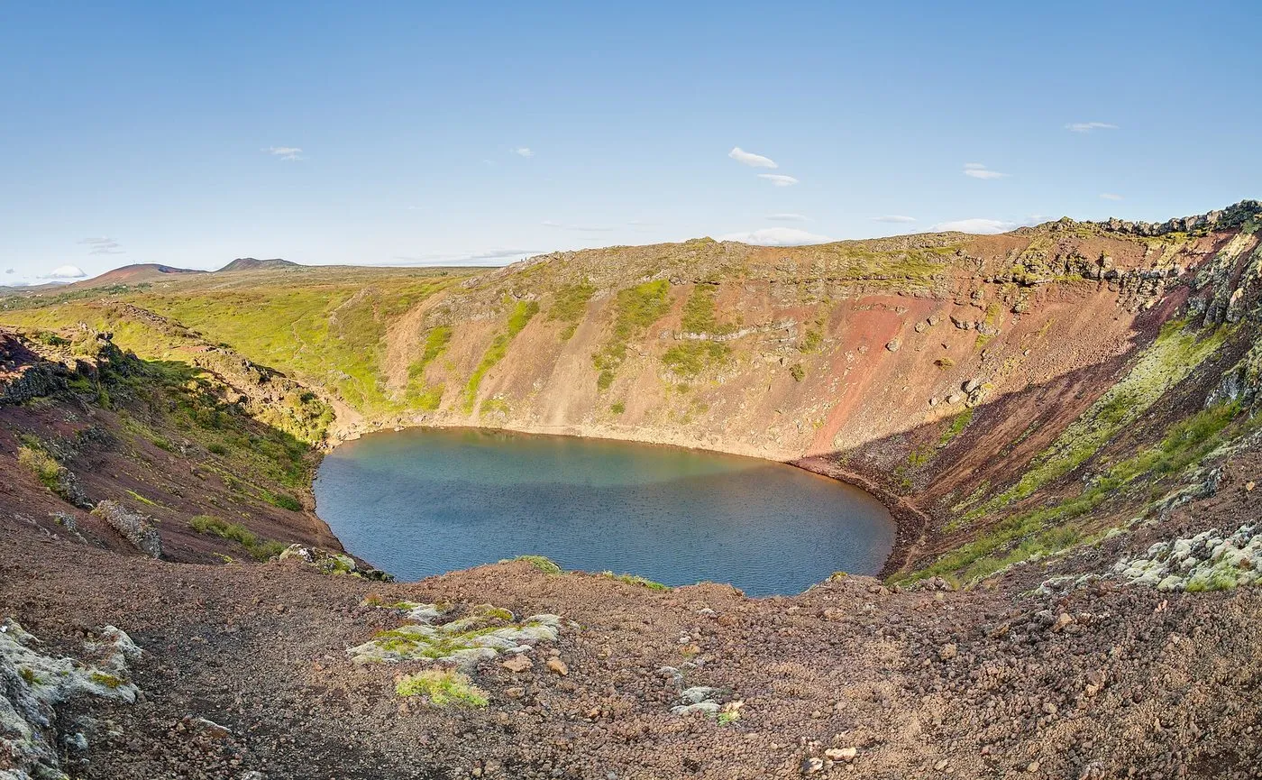 Kerið crater and its lake. Photo: Diego Delso, Wikimedia Commons, CC BY-SA 4.0.
Stop 4: Kerið Volcanic Crater
Located on Route 35, 55 kilometres south of Gullfoss, Kerið is a volcanic explosion crater caldera formed approximately 6,500 years ago during the eruption of the Grímsnes volcanic field.
Unlike typical explosive maars that blow volcanic ash outward, geologists believe Kerið was created when a small magma chamber emptied during a steady eruption, causing the overlying cone of red basaltic rock to collapse inward. The caldera measures roughly 55 metres deep, 170 metres wide, and 270 metres long.
At the base of the caldera lies a vivid aquamarine lake, whose water level matches the local underground water table. A smooth circular gravel trail circles the rim of the crater in approximately 15 minutes, while a wooden staircase leads down to a viewing bench at the water’s edge.
Entrance fee: Because Kerið is situated on privately owned family farmland rather than public municipal soil, visitors pay a 700 ISK service fee at the entrance.
Tour options and bookings
If you prefer to avoid the stress of driving on icy sub-arctic roads, navigating parking payment apps, or managing petrol logistics, booking a guided day tour avoids all three.
Reykjavik: Golden Circle Full-Day Tour with Kerid Craterad
From 11,300 ISK · 4.8 stars from 28,024 reviews · 7–8.5 hours · Instant confirmation
The standard Golden Circle coach tour. It covers Þingvellir National Park, the Strokkur geyser at Haukadalur, Gullfoss waterfall and admission to Kerið crater; Þingvellir National Park, the Strokkur geyser at Haukadalur, Gullfoss waterfall, and admission to Kerið crater. Travel aboard a spacious coach equipped with an onboard audio guide in 10 languages, free Wi-Fi, and USB charging outlets, with convenient pickups from designated tourist bus stops in Reykjavik.
From Reykjavik: Golden Circle, Kerid & Secret Lagoon Tourad
From 16,500 ISK · 4.8 stars from 6,589 reviews · 10 hours · Geothermal soak
Enhance your sightseeing loop by capping the afternoon with a relaxing soak in the Secret Lagoon (Gamla Laugin) in Flúðir. Built in 1891, the Secret Lagoon is Iceland’s oldest communal swimming pool, kept at a constant 38°C to 40°C by neighbouring boiling natural springs. The package includes round-trip transport, all park admissions, and Secret Lagoon admission.
Reykjavik: Golden Circle, Kerid Crater & Blue Lagoon Tourad
From 30,500 ISK · 4.9 stars from 6,189 reviews · 11 hours · Combined admission
A day trip that pairs the Golden Circle with an evening in the milky-blue water of the Blue Lagoon. Includes round-trip transport, Kerið entrance, and pre-reserved Comfort admission with a silica mud mask, towel, and in-water drink.
Self-drive route additions: greenhouses and secret baths
Travellers exploring by rental vehicle have the flexibility to add food and thermal detours along the southern segment of the loop:
Friðheimar Tomato Greenhouse (Reykholt)
Located on Route 35 in Reykholt, 25 kilometres south of Gullfoss, Friðheimar is an innovative horticultural farm where succulent vine tomatoes are grown year-round inside colossal glass greenhouses powered entirely by geothermal boreholes and green hydroelectric lighting.
Guests dine at wooden tables arranged directly between rows of fragrant two-metre-tall tomato vines. The signature offering is an all-you-can-eat fresh tomato soup served with artisan sourdough loaves, fresh basil, and cucumber salsa. Because commercial tour groups regularly stop here, reserving a dining table several weeks in advance via Fridheimar.is is essential.
Laugarvatn Fontana Geothermal Baths
Positioned on the shores of Lake Laugarvatn on Route 37, midway between Þingvellir and Geysir, Fontana features steam rooms built directly over boiling thermal vents, three mineral soaking pools, and cold-water lake plunge access. Every afternoon at 14:30, staff demonstrate the baking of traditional Icelandic rye bread (hverabrauð), buried in the hot geothermal black sand for 24 hours.
Practical self-drive advice
- Petrol and EV Charging: Fuel stations are located along the route at Geysir, Reykholt, and Selfoss. Automated pumps accept chip-and-PIN credit cards. Fast-charging DC stations for electric vehicles are situated at Þingvellir, Geysir, and Selfoss.
- Clothing and Gear: Weather along the southern lowlands can change rapidly from calm sunshine to gale-force sleet. Bring sturdy waterproof walking boots with rubber grip, a windproof and waterproof outer jacket, a fleece mid-layer, and warm gloves. In winter, pack clip-on microspikes for icy paths around Gullfoss and Kerið.
- Road Safety: Check the live traffic cameras and snow clearance updates on Umferdin.is before pulling out of your hotel car park, especially between October and April.
For more day excursion ideas across southern and western Iceland, consult our overview of day trips from Reykjavik, as well as our detailed guides to the South Coast day trip and Snæfellsnes Peninsula day trip.
Common questions
How long does driving the Golden Circle take from Reykjavik?
The classic Golden Circle route covers approximately 240 kilometres of fully paved highway, requiring roughly 3.5 to 4 hours of pure driving time. When factoring in 60 to 90 minutes at each of the three primary stops, plus lunch and a visit to Kerið crater, plan for a total excursion of 7 to 9 hours.
Are there admission or parking charges along the Golden Circle?
Natural attraction entry is free at Þingvellir National Park, Geysir, and Gullfoss. Parking at Þingvellir costs 1,000 ISK per car for the day, covering all the park's car parks. Kerið crater is on private land and charges 700 ISK a person.
Can you drive the Golden Circle safely in winter?
Yes. The entire circuit follows well-maintained, paved roads that are cleared by snowploughs daily. However, winter storms, high crosswinds, and sudden black ice can create challenging driving conditions. Check road conditions at umferdin.is and weather alerts on vedur.is before setting out, or opt for a guided coach excursion.
Which direction is best for driving the Golden Circle?
Driving clockwise is the standard recommendation: depart Reykjavik eastward on Route 36 to Þingvellir, continue to the Haukadalur geothermal valley (Geysir) and Gullfoss, then head south past Kerið crater before returning to the capital via Route 1. Departing by 08:00 allows you to reach Þingvellir ahead of the large commercial tour coaches.